
Jack Thurston, The Guardian, September 23, 2015
Harbour to highlands, Snowdonia
Start Porthmadog
Finish Harlech (train return)
Distance 24 miles
Level Moderate, some big hills
Maps and GPX file
Route
Where to stay
The Victoria Inn, Llanbedr (01341 241213) has rooms from £80 B&B.
Merthyr Farm (01766 780897, from £7 adult, £2 child; open May to 4 October) is a small campsite high above Harlech, with great views.
Where to snack
Hufenfa’r Castell, next to the castle in Harlech, serves possibly the best ice-cream in Wales. It is open daily from 9am-5pm (often later) from 1 April to 30 October.
Heart of stone, Snowdonia
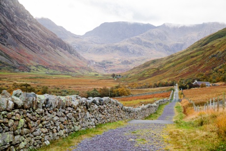
Lon Las Ogwen, Snowdonia
Start/finish Port Penrhyn, Bangor
Distance 22 miles
Level Easy
Maps and GPX file
Route
Where to stay
YHA Idwal Cottage (08453 719744) is the oldest youth hostel in Wales; beds from £22, private rooms from £24pp, camping from £13.
Where to snack
Fitzpatrick’s (9 Ogwen Street, Bethesda) is a friendly, and bright green, cafe just off the route. Open Thurs-Fri 8am-3pm, Sat-Sun 8am-5pm.
Ogwen Snack Bar (Nant Ffrancon, 01248 600683) is a mountaineers’ tea bar right by the mountain rescue base. Open daily 9am-approx 5pm; closed Mon-Thurs late December-end of Jan.
Celtic coast, Pembrokeshire
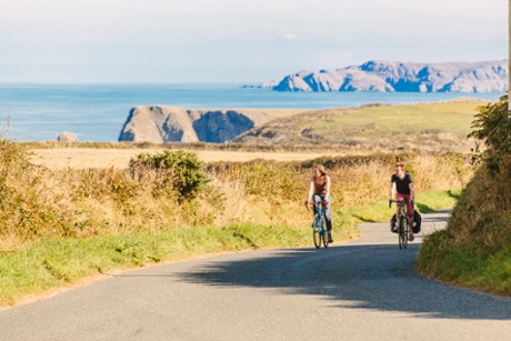
The north Pembrokeshire coast
Start/finish St David’s
Distance 41 miles
Level Challenging
Maps and GPX file
Route
Pembrokeshire’s exceptional landscape features windswept cliffs, huge sandy beaches, tranquil estuaries, marshes and lagoons, craggy gorse-covered hills and rolling farmland. To the east rise the craggy Preseli Hills and in the west are the conical volcanic tors of St David’s Head. The ride begins in St David’s, Wales’s pocket-size cathedral city at the far end of Pembrokeshire’s northern peninsula. St David’s is the ancient capital of the Welsh church and more recently the epicentre of a Welsh gastronomic revival. The route heads to Solva, a long fingerlike inlet, before traversing the peninsula to the lighthouse at Strumble Head. On the return west, the route hugs the northern coast passing the Melin Tregwynt woollen mill before a sequence of coves and beaches – the best of them being the big sandy strand and turquoise lagoon at Abereiddy and the harbour of Porthgain. The return into St David’s comes with a beautiful twist, as you pass the door of the ruins of the once grandiose Bishop’s Palace.
Where to stay
Camping Wild Wales (01348 837892) in Trefin; from £10 adult, £5 child (6-16).
Where to snack
Lavender Cafe (The Old Chapel, Main Street, Solva) is attached to the Raul Speek gallery, run by the Cuban artist. The cafe offers a large selection of vegetarian food and cakes made on the premises, and is open daily 10am-6pm in summer (Mar-September) and 11am-4pm in winter (Oct-Feb); closed Thursdays.
The cafe at Melin Tregwynt, Castlemorris, (01348 891225) serves good locally-sourced food, including cakes, sandwiches and light lunches. Open Mon-Fri 9.30am-5pm, Sat 10am-5pm, Sun 11am-4pm.
The Shed in Porthgain is a quayside spot that bills itself as a fish and chips bistro; open daily noon-3pm and also Tues-Sat 5.30pm-9pm
Cliff and castle, Pembrokeshire
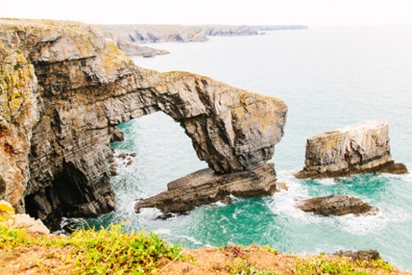
The Green Bridge of Wales
Start/finish: Pembroke
Distance 50 miles
Level Moderate
Maps and GPX file
Route
The 186-mile Pembrokeshire Coast Path is the jewel in the crown of Britain’s only coastal national park. Unfortunately, due to the narrow tracks, steep gradients and precipitous cliffs, only a very short section is open to cyclists. This ride takes in that section, which runs for four miles from the sea stacks and the Green Bridge of Wales sea arch to the tiny chapel of St Govan’s, wedged into a cleft in the limestone cliffs. The route begins in Pembroke and on its way out of the town passes the imposing Norman fortress that’s the only castle in Wales never to have succumbed to attack and the birthplace of Henry Tudor, who landed his invading army (from France) at nearby Milford Haven in 1485. The route makes a loop to Angle and the big sandy beach at West Angle Bay before crossing the dunescape of Brownside Burrows towards the Castlemartin Firing Range (check firing times to ensure it’s open, weekends are fine). The rough gravel track along the cliffs is the highlight of this ride, with burned-out tanks on the left and an expanse of blue sea to the right. From St Govan’s the route heads north through Bosherston (another great beach is nearby at South Broad Haven), then Stackpole and a final up-and-down run back to Pembroke.
Where to stay
The Stackpole Inn, Jason’s Corner, Stackpole, (01646 672324) is a pretty pub with award-winning food and double rooms from £90 B&B.
Where to snack
The Old Point House, Angle Point, (01646 641205) on Angle Bay, is a farmhouse pub, dating back to around 1500. It has an extensive pub-grub menu with excellent fish dishes. Open daily noon-10pm (food served till 2.30pm, and from 6.30pm-8.30pm)
Cawdors Tea Rooms on the Stackpole Estate serves food (some, such as its cheese, locally sourced) from an historic kitchen garden. Open daily 10am-5pm, 1 Mar-30 October.
Three peaks, Brecon Beacons
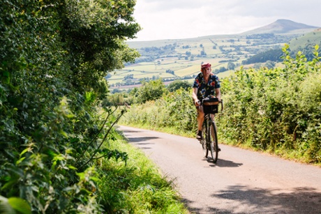
Near Abergavenny with the Sugar Loaf in the background
Start/finish Abergavenny
Distance 38 miles
Level Challenging (though it’s possible to avoid the last big climb)
Maps and GPX file
Route
Abergavenny nestles beneath three prominent peaks at the south-eastern edge of the Brecon Beacons national park: the Blorenge, the Skirrid and the Sugar Loaf. This ride takes in fine views of all three. It begins by skirting the slopes of the Skirrid. Crossing the valley of the Gavenny river, the ride heads to the old charcoal-making centre of Forest Coal Pit from where it’s a scenic diversion to the tiny church, holy well and hermit shrine at Patricio and around steep-sided valleys of the Grwyne river, whose clear waters tumble down to join the river Usk at Glangrwyney. After crossing the valley floor the route makes use of the Monmouth and Brecon Canal to round the lower slopes of the Blorenge, with stunning views back over the valley. Mountain goats now shift into their lowest gear for the big climb to the summit of the Blorenge (it’s an optional extra as the canal route does offer an easy return to Abergavenny). The Tumble climb is a regular fixture in professional bike races, such as the Tour of Britain, but this route takes in a lesser-known but more interesting route up, known locally as the Tyla, passing through the industrial landscape of Blaenavon, a Unesco world heritage site. From the summit road on the Blorenge it’s a white-knuckle descent along lanes lined by gnarled old beech trees and finally a short ride across the meadows into the centre of Abergavenny, arriving beneath the walls of the town’s ruined castle.
Where to stay
Middle Ninfa Farm, Llanellen (01873 854662), is a tiny campsite with a bunkhouse on a small organic farm on the east face of the Blorenge; camping from £5pp, children £2.50, bunkhouse £15pp.
Golden Grove campsite in Llangenny, (01873 812061), is a small site next to The Dragon’s Head pub (01873 810350).
Where to snack
Lamb and Fox Inn, Pwll Ddu (07790 682832). This is a low-ceilinged old miners’ and quarrymen’s pub with beer from the local Rhymney Brewery, pub grub, and wood fires. Open Fri 6.30pm-11pm, Sat 3pm-11pm, Sun noon-10.30pm.
- Lost Lanes Wales: 36 Glorious Bike Rides in Wales and the English Borders by Jack Thurston (£14.99, Wild Things Publishing) is out now. For 30% off and free UK p&p visit wildthingspublishing.com and enter Guardian as your coupon code
This article originally appeared on guardian.co.uk
This article was written by Jack Thurston from The Guardian and was legally licensed through the NewsCred publisher network.
![]()